 The blog post, second of three, was written by Xavier Courouble, research assistant for Sailors and Daughters: Early Photography and the Indian Ocean, an online exhibition part of the Smithsonian’s National Museum of African Art’s Connecting the Gems of the Indian Ocean: From Oman to East Africa. Read the first post in the series here.
From 1836 to 1848, successively in command of the corvette “La Prévoyante,” “La Dordogne,” and finally the frigate “Le Ducouëdic,” Charles Guillain (1808-1875) navigated the Indian Ocean from the Cape of Good Hope to the western coast of the Indian sub-continent. During his several missions he accumulated extensive knowledge on Zanzibar, Madagascar, the Comoros, as well as the Swahili and Somali coast of Africa. Accounts of these expeditions were all published and gave this St. Simonien a solid reputation of ethnologist and geographer. Yet a certain degree of confusion remains of the political and commercial purposes of his ambitious campaigns of exploration, influenced by personal convictions, regional aspirations, and France’s global interest in the region.
The copies held at the Warren M. Robbins Library at the National Museum of African Art of Guillain’s magisterial three-volume work were recently digitized. This includes Documents sur l’histoire, la géographie, et le commerce de l’Afrique orientale and the accompanying atlas folio of lithographs and map engravings, Voyage à la côte orientale d’Afrique.

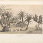
(Vue d Dzaoudzi en 1846, l’un des ilots voisins de Maïotte.)
E. Cicéri, lithograph ; L. Caraguel and H. Bridet, drawings ; Arthus Bertrand, editor.
In: “Voyage à la côte orientale d’Afrique” / surveyed and written by Ch. Guillain, folio-atlas, plate 3;
1856-1857.
Guillain’s Three-Volume Publication and Accompanying Atlas Folio
In the first half of the nineteenth-century, the French Ministère de la Marine, and its hydrographical office, taking advantage of new recording methods and technologies, made outstanding progress in the field of coastal mapping. Therefore, in response to a reduced presence in the Pacific and Indian oceans as well as in face of its own public opinion, it shifted its focus on the publication of the accomplishments of its geographers and the accounts of scientific voyage and discoveries.
The French Ministère de la Marine, with the financial revenue from its subscribers, heavily funded these luxury publications of travel narratives. They were distributed through the unofficial section of the Annales maritimes et coloniales, to members of the French government, selected high-profile personalities, major libraries throughout France, as well as to European governments and relevant foreign scientists, making this enterprise a very expensive communication campaign.
French editors, drawn by a highly sought-after carte-de-visite, acknowledged the opportunity and competed harshly among themselves to produce the most lavish publication, sometimes deflating the number of volumes to excessive extent. For example, the three-volume work Documents sur l’histoire, la géographie, et le commerce de l’Afrique orientale and the accompanying atlas folio of lithographs and map engravings, Voyage à la côte orientale d’Afrique, published in 1856-1857 by French editor Arthus-Bertrand, saw well-known Parisian artists contributing handsome tinted lithographed plates after the expedition’s drawings and daguerreotypes. Drawings of coastal and city views made by Caraguel and Bridet, were prepared by landscape lithographers, Jean-Baptiste Léon Sabatier, Louis-Julien Jacottet, and Eugène Cicéri. Maps, surveyed by the officers of “Le Ducouedic,” were finalized by Charles-Etienne Collin, a third generation cartographer related to Charles-Francois Beautemps-Beaupré, the father of modern French hydrography. Finally, several photographic portraits taken by Charles Guillain were drawn by Adolphe Jean Baptiste Bayot, an experienced lithographer who had just completed a series of lithographs for the 1851 Kendall & Nebel’s folio book, The War between the United States and Mexico illustrated.
In 1985 Janet Stanley, Librarian at the Warren M. Robbins Library, National Museum of African Art, visited several Africana book dealers throughout Europe in order to build the collection of the Library before the opening of the museum on the National Mall in 1987, now part of the Smithsonian Institution. Among others, she acquired this first edition three volumes octavo & folio atlas from Jean-Denis Touzot Libraire in Paris. According to Dr. Lilla Vekerdy, Head of The Dibner Library of the History of Science and Technology, Smithsonian Libraries, the set, in remarkable condition, comes with an handsome period style brown gilt tooled quarter morocco with marbled boards and green vellum tips. The folio atlas contains eleven engraved maps (five folding) and forty-five three-tone tinted lithographed plates, some displaying creative shadowing and shading techniques common to a mid-nineteenth century period of transition and experimentation in lithographic process.

(Carte générale de l’Océan Indien.)
Bineteau, printing, Paris.
In : “Voyage à la côte orientale d’Afrique” / surveyed and written by Ch. Guillain, folio-atlas, plate 1;
1856-1857. Map, engraving.
Chronology of Guillain’s 1846-1848 Campaigns of Exploration
• Mid-May 1846, Charles Guillain, in command of the French frigate “Le Ducouëdic,” arrived to Réunion (Bourbon) to accomplish a campaign of exploration along the east coast of Africa.
• September 16, 1846 to October 10, 1846, Guillain first visited the island of Mayotte before sailing up north to Zanzibar, to engage in diplomatic and commercial discussions with the Sultan of Oman.
• October 10, 1846 to January 4, 1847, “Le Ducouëdic,” sailed in direction to the western coast of the Indian subcontinent, visiting the coastal cities of Diu, Surat, Mumbai (Bombay), and Goa.
• January 4, 1847 to March 25, 1847, Guillain explored the Somali coast, visiting the cities of Cap Guardafi (Ras Hhafoun), Berbera, Mogadishu (Mogedchou), Gondeurcheikh, and Merka (Meurka).
• March 5, 1847 to March 13, 1847, Guillain and seven members of his crew went on a journey into the Somali hinterland to meet Yusuf Mahamud, the Sultan of Geledi.
• March 25, 1847 to May 2, 1847, Guillain, in command of “Le Ducouëdic,” was forced to suspend the expedition campaign because of death and diseases affecting the sailors and their officers. The recovery was spent at Mahé in the Seychelles.
(First interruption of the campaign)
• May 13, 1847 to June 17, 1847, Guillain accompanied Amiral Cécille on a tour of inspection to the island of Ste Marie (Madagascar).
• June 17, 1847 to November 17, 1847, Guillain served as ad interim naval commander of the station of Réunion (Bourbon).
• June 17, 1847 to September 13, 1847, Guillain, in his capacity of naval officer of the Ministère de la Marine, presided over the Commission of Evaluation of the Emancipated Slaves in Mayotte.
• August 25, 1847 to November 17, 1847, Guillain instructed Captain Sévin, then in command of the French corvette “Le Voltigeur”, and Mr. Loarer, French commercial attaché, to explore the coast of Mozambique.
• September 13, 1847 to September 29, 1847, Guillain, in command of “Le Ducouëdic,” visited the Comoros islands of Anjouan and Moheli before sailing to Zanzibar.
• September 29, 1847 to October 13, 1847, Guillain visited Zanzibar to handle the affairs of the French consulate after the death of Mr. Broquant.
• October 13, 1847 to November 13, 1847, Guillain sailed to the Seychelles to recover from severe illness.
(Second interruption of the campaign)
• January 5, 1848 to March 1, 1848, Guillain boarded a small Arab dhow to explore again the Somali coast, visiting the cities of Ouarcheikh, Mogadishu (Mogedchou), Merka (Meurka), and Brawa (Braoua, Brava).
• March 1, 1848 to March 24, 1848, Guillain, back on “Le Ducouëdic,” was forced to suspend the expedition because of death and diseases affecting the sailors and their officers. Sixteen men had already died in the course of the mission. Again, recovery was spent at Mahé in the Seychelles.
• April 21, 1848 to May 8, 1848, Guillain visited Zanzibar for the last time.
• May 8, 1848 to May 31, 1848, Guillain visited Mombasa and its dependencies. His investigations into the manners and customs of the local inhabitants as well as the reports on the several caravans coming from the interior proved to be very useful.
(Third and final interruption of the campaign)
• June 19, 1948, Guillain’s mission of exploration of the east coast of Africa was terminated. It had lasted for 22 months, often interrupted by official requisition orders from the station of Réunion (Bourbon) as well as by difficult circumstances and an unhealthy climate affecting sailors and officers of the frigate “Le Ducouëdic.”

J. Jacottet, lithograph ; L. Caraguel and H. Bridet, drawings ; Arthus Bertrand, editor.
In : “Voyage à la côte orientale d’Afrique” / surveyed and written by Ch. Guillain, folio-atlas, plate 4;
1856-1857.
Guillain’s Previous Expeditions in the Indian Ocean
• October 15, 1835, Charles Guillain left France for Réunion (Bourbon) where he arrived on January 18, 1836.
• May 1837, the French corvette “La Prévoyante,” now under the command of Charles Guillain, was sent on a mission along the St. Augustine’s Bay of Madagascar, to re-establish amicable intercourse with the Sakalavas, which had been interrupted, owing to illicit proceedings of French planters from Mauritius. The account given of his successful mission already included the manners and customs of this extraordinary Malagasy nation.
• July 1838, Guillain was sent on a mission to Zanzibar to establish diplomatic relations and formal trade agreements with the Sultan of Oman. The unsuccessful mission only resulted in a vague promise by the Omani ruler to welcome a French consul in his territories.
• April 1840 to January 1841, Guillain, then in command of the French corvette “La Dordogne,” was sent back on a mission to Zanzibar, ultimately sailing to Muscat, to persuade the Sultan of Oman to receive the newly appointed French consul Mr. Noel. The unsuccessful mission only resulted in a trade agreement in favor of French planters in Réunion (Bourbon) and formal visits to several harbors along the east coast of Africa.
• February 1841 to July 1841, Guillain was involved in establishing a permanent settlement at Nossi-Bé (Madagascar). The difficulties of the previous mission and the unhealthy climate resulted in the death of 35 sailors.
• August 1842 to January 1843, Guillain was sent on a mission to explore the west coast of Madagascar, to identify resources that could provide the merchants of the French-occupied islands of Nossi-Bé and Réunion (Bourbon) with opportunities for trade and investment. A partial account given of the mission was published in 1845 in Documents sur l’histoire, la géographie et le commerce de la partie occidentale de Madagascar.
• May 18, 1843, Guillain left Réunion (Bourbon) for France where he arrived on September 4, 1843.

(Plan de Zanzibar, 1846.)
Erhard Schieblé; Kœppelin, printing ; Arthus Bertrand, editor.
In : “Voyage à la côte orientale d’Afrique” / surveyed and written by Ch. Guillain, folio-atlas, plate 9;
1856-1857. Map, engraving.
Online Resources:
– SWAHILI COAST: EXPLORATION BY FRENCH CAPTAIN CHARLES GUILLAIN, 1846-1848. Blog post, part 1/3, written by Xavier Courouble. Accessible here on Blog.library.si.edu
– SWAHILI COAST: EXPLORATION BY FRENCH CAPTAIN CHARLES GUILLAIN, 1846-1848. Blog post, part 3/3, written by Xavier Courouble. Forthcoming.
– DOCUMENTS SUR L’HISTOIRE, LA GEOGRAPHIE ET LE COMMERCE DE L’AFRIQUE ORIENTALE, by Charles Guillain, 1856; Arthus Bertrand, Editor, tome 1. Accessible here on library.si.edu/digital-library
– DOCUMENTS SUR L’HISTOIRE, LA GEOGRAPHIE ET LE COMMERCE DE L’AFRIQUE ORIENTALE, by Charles Guillain, 1856; Arthus Bertrand, Editor, tome 2, part 1. Accessible here on library.si.edu/digital-library
– DOCUMENTS SUR L’HISTOIRE, LA GEOGRAPHIE ET LE COMMERCE DE L’AFRIQUE ORIENTALE, by Charles Guillain, 1856; Arthus Bertrand, Editor, tome 2 , part 2. Accessible here on library.si.edu/digital-library
– VOYAGE À LA CÔTE ORIENTALE D’AFRIQUE, by Charles Guillain, 1856; Arthus Bertrand, Editor, folio atlas. Accessible here on library.si.edu/digital-library
– Charles Guillain’s daguerreotypes, taken along the east coast of Africa in 1847 and 1848, are accessible here on the Iconothèque du Musée du Quai Branly
– DOCUMENTS SUR L’HISTOIRE, LA GEOGRAPHIE ET LE COMMERCE DE La Partie Occidentale de Madagascar, by Charles Guillain, 1845; Extrait des “Annales maritimes et coloniales.” Accessible here on Archive.org
– SAILORS AND DAUGHTERS: EARLY PHOTOGRAPHY AND THE INDIAN OCEAN, an online exhibition curated by Erin Haney, Ph.D., with the assistance of Xavier Courouble, part of the Smithsonian National Museum of African Art’s programming for Connecting the Gems of the Indian Ocean: From Oman to East Africa. Accessible on indian-ocean.africa.si.edu
Bibliography:
– BARTHE Christine, Monnier J., Camera Obscura : Premiers Portraits au Daguerréotype 1841-1851, Paris, Edition Nicolas Chaudun et Musée du Quai Branly, 2007. PDF file accessible here
– CHAPUIS Olivier, A la mer comme au ciel, Beautemps-Beaupré et la naissance de l’hydrographie moderne (1700-1850); Collection “Histoire maritime”, Presses de l’Université de Paris-Sorbonne, 1999. See preview here
– GUILLAIN Charles, Documents sur l’Histoire, la Géographie et le Commerce de l’Afrique Orientale; Arthus Bertrand, Editor, 1856.
– GUILLAIN Charles, Documents sur l’Histoire, la Géographie et le Commerce de la Partie Occidentale de Madagascar; Extrait des “Annales maritimes et coloniales”, 1845.
– REUILLARD Michel, Les Saint-Simoniens et la Tentation Coloniale: Les Explorations Africaines et le Gouvernement Néo-Calédonien de Charles Guillain, Editions L’Harmattan, 1995. See preview here
– RISPAL Jean-François, Zanzibar et la Politique Française dans l’Océan Indien 1776-1904, Recherches en anthropologie et en histoire de l’Afrique, RAHIA No.15, Centre d’Etude des Mondes Africains (CEMAF) MMSH, Aix-en-Provence, 2005. PDF file accessible here
4 Comments
Thanks for sharing . It is very useful especially for me …
The mission of exploration of the frigate “Le Ducouëdic,” requested 236 men in order to consistently keep a crew of 122 sailors, among them 20 Malagasy people. A non-definitive list of officers includes:
– Guillain, Charles (Capitaine de frégate) (1808-1875)
– Sevin, Auguste (Lieutenant de vaisseau)
– Bridet, Hilaire Gabriel (Lieutenant de vaisseau) (1818-1894)
Grasset, Marie Bruno Ferdinand (Enseigne de vaisseau, 1ère classe; puis Lieutenant de vaisseau in 1847) (1817-1894)
– Riondet, Eugène (Enseigne de vaisseau, 1ère classe) (1822-1892)
– Caraguel, Léon-Exupère Hippolyte (Enseigne de vaisseau, 1ère classe) (1822-1862)
– Calvet, Bernard (Enseigne de vaisseau, 1ère classe)
– Longchamps (Elève de 1ère classe)
– Pierre (Elève de 1ère classe)
– Jehenne, Louis Auguste (Elève de 2ième classe) (1828-1894)
– Vernet, Jean-Louis (Premier maitre de timonerie)
– Dr. Bertrand (Médecin-chirurgien)
– Dr. Thomas (Médecin-chirurgien)
– Loarer, Edouard (Attaché commercial, Ministère Francais du Commerce)
– Vignard, Prudent(?) (Interprète en langue Arabe)
– Boivin, Louis Hyacinthe (Botaniste)
great content, very useful for me 🙂
What an amazingly detailed and enriching account. Would like to see more of your work, Xavier.